 Space junk orbiting around Earth
While congestion in low Earth orbit (LEO) is sparking serious conversations about space sustainability, 2023 marked huge strides with the investment in — and the enhancement of — automation technologies that could markedly improve space situational awareness and safety.
Given the research firm NSR’s projection that manufacturing and launch order volumes will skyrocket to 24,700 by 2030, the timing couldn’t be more critical.
Advancements in the commercial computer information technology sector, in particular, have fueled the satellite industry’s progress, perhaps more so than government investment, says Brian Weeden, Director of Program Planning for Secure World Foundation. Additionally, the formation of global consortiums such as the Space Data Association are also furthering space situational awareness by supporting the advancement of automation.
“All these companies have some combination of tracking hardware, but also software platforms,” says Weeden. “Honestly, the software’s where a lot of the innovation is happening.”
Mekhi Dhesi, Space Situational Awareness (SSA) Team Lead and Bid Manager for Astroscale, echoed the importance of investing in automation now to protect space in the future.
“There will come a time in the not-too-distant future where operators need to make multiple collision avoidance maneuvers a day to stay safe,” says Dhesi. “Automation of these collision warnings and subsequent avoidance maneuvers will be essential, as (if things continue the way they are) the human operator will not be able to handle them all manually.”
Helping Operators Maneuver
Araz Feyzi, co-founder and CTO, Kayhan Space, hopes his company will help to bring order to the “lawless highway” of space through the third iteration of its signature platform, the Pathfinder 3.0.
The Pathfinder 3.0 improves on previous iterations with the ability to autonomously pre-coordinate maneuver responsibility and event mitigation status at the machine-to-machine level using the Space Safety Coalition (SSC) Best Practices for the Sustainability of Space Operations.
“More recently, because of the increased congestion in Low Earth Orbit, there’s been a rapid increase in conjunctions when [multiple] operators have operational satellites,” says Feyzi. “There’s a need for a kind of Switzerland of data in the space industry. You have all these commercial data providers, whether with their radars or telescopes or other sensors, track satellites and other objects. So, there’s a need for a neutral third party to come in and say, ‘Okay, so let’s compare these and let’s see whose data is more accurate and whose data is reliable.’”
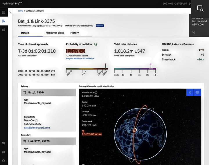 Kayhan Space’s Pathfinder 3.0 is designed to be the industry’s first autonomous space traffic coordination framework for spaceflight safety. (Source: Kayhan Space)
Feyzi offers the hypothetical example of a U.S. satellite operator that has a high-risk conjunction event — an imminent collision — with another satellite that’s operated by a European operator in a different time zone. Prior to automated platforms, these two operators would have relied on phones or emails to communicate back and forth, thus delaying actions.
“Today, we have a couple of bilateral agreements between operators - for example, NASA and SpaceX have agreed that if a NASA asset has a conjunction with a SpaceX asset, the SpaceX satellite will move,” says Feyzi. “But as you can imagine, this is not scalable in any form or shape - we have hundreds of operators out there.”
Ideally, operators would share information on a cloud-based software platform, like Pathfinder, which would analyze data from multiple sources — from radar readings or public information from the U.S. Space Command’s high-fidelity space catalog — and offer smart recommendations that help operators determine when it’s not in their best interest to maneuver space assets.
“We can recalculate the probability of collision, and hypothetically speaking, the probability of collision can go down by like a factor of 100,” says Feyzi. “All of a sudden, because we have less uncertainty and we have more precise data on both parties, we realize that the risk of collisions isn’t actually that high … So both parties may agree not to perform a maneuver. And that’s actually of huge value.”
Astroscale, too, is focusing on helping operators, for example, by improving onboard data processing.
“We have been in discussion with several governments interested in the ability to inspect and characterize on-orbit objects and the space around them,” says Dhesi. “One specific area of focus for our SSA work has been how best to quantify the tumble-rate of on-orbit objects, using SSA data.”
Astroscale’s ADRAS-J mission, an in-space situational awareness (ISSA) mission that will perform complex rendezvous-proximity operations (RPO) to perform close-range inspection of a Japanese upper-stage rocket body, is scheduled to launch at the end of 2023.
“This will allow advanced characterization of the body, with the aim to actively de-orbit in a follow up mission,” Dhesi says, adding that the Astroscale Japan team also received funding of up to $80 million to develop an on-orbit inspection demonstration mission that will image and diagnose a large, defunct satellite in space.
“Automation is also critical to integrate separate pieces of the SSA picture,” says Michael Clonts, Director of Space Domain Awareness (SDA) Initiatives at Kratos Defense. “For example, changes detected in RF communication patterns may indicate a satellite maneuver is imminent. How do we automate data sharing and processing between government and commercial parties who need this information quickly? This presents a huge challenge — and opportunity — that the SSA community is actively working out.”
Leveraging Radar to Advance Autonomy
LeoLabs is focused on delivering actionable SSA data to satellite operators in LEO and reducing latency by advancing automation. To accomplish this, the seven-year-old satellite SSA provider utilizes global ground-based radar network, which provides a life cycle of space safety services in LEO.
The company uses a vertically integrated space operations stack which includes autonomous radar operations and cloud data platform, says Dr. Rachit Bhatia, Space Safety Analytics and Research Lead. This ensures continuous operations, low latency and quick scalability, says Bhatia, adding that this has helped to track and characterize all LEO objects, generate alerts for unexpected threats and assess evolving risk due to debris and rocket bodies.
“We want to track all of the objects but also track them multiple times in a day because objects in low Earth orbit get impacted by atmospheric drag and other perturbations,” says Bhatia. “Hence it is important that when we are tracking them multiple times, we ensure that we maintain small uncertainty on the track and effectively detect changes in the nominal trajectory. And that is why a global radar network becomes significant.”
But while advancements such as these are noteworthy, and the space sector is making measurable progress — for example, in the accuracy of SSA data catalogs and conjunction data messages, and the applicability of machine learning/AI to SSA applications — automation has room for improvement.
“SSA sensors, both ground-networks and on-orbit. need to continue to improve, to be able to routinely track smaller objects,” says Dhesi. “Automation capabilities need to improve to the level we can be confident in their application. Finally, the space sector needs to reduce the amount of debris on orbit, so that our SSA can better stay on top of the current and growing activity in space.”
Explore More:
Podcast: Tracking LEOs, Growth in Resident Space Objects and the Problem with Uncertainty
DoD’s Commercial Space Domain Awareness Dilemma
Podcast: Collision Avoidance Services and Space Domain Awareness
DoD’s Increasing Demand for Data Fusion in Space