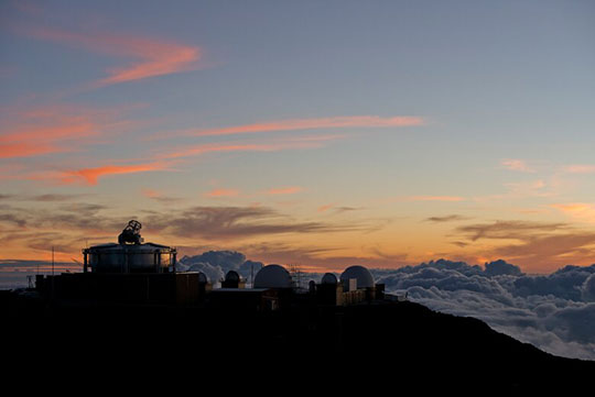
 Maui Space Surveillance Complex. Credit: U.S. Air Force/Tech. Sgt. Bennie J. Davis III
WASHINGTON — In space, situational awareness is everything. Whether it’s military mission, space traffic management or protecting spacecraft from orbital debris, without the right combination of sensors and analytic capabilities, you’re flying blind.
Until recently, Space Domain Awareness (SDA) has not received as much attention or investment as other space activities. Now, with the number of satellites projected to exceed 100,000 by the next decade, companies, governments and investors are becoming more attuned to the need for real-time, operational SDA data. Many are pushing the boundaries of traditional technology to acquire it.
For the most part, SDA relies on three technologies capable of observing various frequencies: electro-optical, radar and radio frequency sensing. No single sensor can provide a complete picture of the space environment by itself. Each sensor has its strengths and limitations in different conditions. Combined, the different solutions support each other by corroborating observations, filling in gaps and generating a wealth of data that is becoming increasingly available to the spacefaring community.
Electro-Optical Sensors: Eyes on the Night Sky
Electro-optical sensors and telescope networks collect a range of photometric, radiometric and spectroscopic data to track and correlate objects at a distance. These highly sensitive instruments can detect objects as small as 10 cm in GEO altitudes and are used across the orbits. Many telescope networks can produce hundreds of thousands of observations in a night to provide total search coverage of a given orbit. Above other technologies, electro-optical sensors are the most reliable methods for identifying and tracking dead satellites and orbital debris at high altitudes, making them a critical component of SDA.
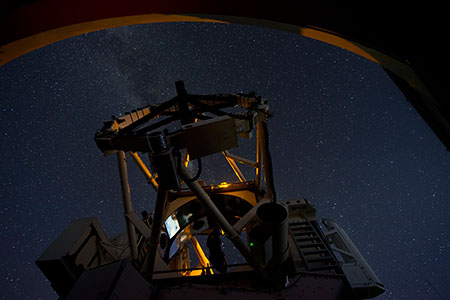 Advanced Electro-Optical System telescope. Credit: U.S. Air Force/Tech. Sgt. Bennie J. Davis III
Despite their high accuracy, ground-based electro-optical sensors are susceptible to atmospheric disturbances and typically cannot operate in daylight. Additionally, even the most powerful ground-based telescopes cannot distinguish between closely spaced objects in geosynchronous orbit. High-resolution imaging and spectral analysis can provide clarity, but the limitation can affect the ability to maintain custody of a satellite or other object. Laser-based technologies can obviate some light and atmospheric disturbances.
In February, the European Space Agency (ESA) began operating the Izaña 1 (IZN-1) laser ranging station in Tenerife, Spain, which is designed to collect observations in daylight. IZN-1 is an optical platform that uses conventional lasers to send pulses of light to illuminate satellites outfitted with retroreflectors. Canada’s NorthStar Earth & Space is outfitting a network of satellites with space-based optical sensors to observe LEO collision risks while avoiding the pitfalls of a ground-based system.
On the Radar in All Orbits
Radar sensors use at least one transmitter and receiver to emit and receive microwave energy as observation vectors to help determine an object’s location, velocity and size. Tracking radars are traditionally most effective at detecting and monitoring objects in lower orbits, like LEO. Only the more powerful radar systems can penetrate high altitudes. Phased-array radars, like the ones used by the U.S. Space Surveillance Network, utilize electronically timed signals to cover large areas in a fraction of a second, making it easier to track multiple satellites simultaneously.
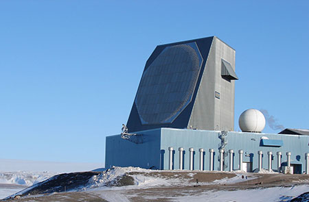 Ballistic missile early warning radar. Credit: U.S. Air Force/1st Lt. Lisa Meiman
Radar has an advantage over telescopes because it can collect data anytime day or night, under all atmospheric conditions. Its limitations are in the transmitter's power to emit a signal strong enough to penetrate higher orbits. Radar also fails to reliably distinguish between two or more closely spaced objects, particularly in GEO.
Technological advances, like the Space Force’s Deep-Space Advanced Radar Capability (DARC) are improving radar surveillance at higher altitudes. The Northrop Grumman-built DARC will be able to monitor geosynchronous and geostationary orbits above 35,000 km when it comes online in 2025. Radar has a high barrier to entry and is the costliest SDA technology to acquire independently. Initiatives like the Unified Data Library, run by the U.S. Space Force, have made radar sensor data more readily available to users at different classification levels. In April, Space Force began feeding observational data to the UDL from the Lockheed Martin-built Space Fence, a highly advanced ground-based radar capable of detecting marble-sized debris in low, medium and geosynchronous orbit.
Filling in the Gaps with RF Sensing
Like other technologies, RF sensing can be done using ground or space-based systems. Ground-based RF sensors can accurately identify and track downlink radio frequencies emitted by satellites, while space-based sensors catch uplink signals from positions on Earth. Unlike optical and radar systems, RF can monitor signals in orbits up to geostationary at all times of day and in all weather conditions. The ability to read unique RF signatures allows persistent custody of spacecraft and discernment of multiple closely spaced objects. The technology recognizes satellite face more threats than just collision.
Analysis of RF signals can help recognize signal jamming, system failure and intentional or accidental interference, as well as revealing communications patterns, patterns of payload use and anomalies.
However, RF monitoring is unable to detect objects that do not emit a signal, such as space debris or dead satellites. The application of RF to SDA has also been relatively recent, due largely to improvements in sensor coverage and more robust infrastructure. Effective RF sensing depends on having enough sensor coverage in space or on the ground to observe uplink or downlink signals.
Ground-based RF developers like Kratos, have developed an extensive global sensor network to monitor the entire geostationary arc. HawkEye 360 and other space-based RF developers have upwards of 10 LEO satellites monitoring ground-based signals. Together, ground and space-based RF provide complementary capabilities to create a complete picture of RF spectrum usage for defense, intelligence and commercial users.
A Dynamic SDA Investment Landscape
The world of SDA is expanding rapidly, and investors are taking note. As more users deploy satellites and the barrier to entry in space is lowered, observational data about that operating domain is becoming more valuable. Demand for real-time sensor data is growing as commercial and government operators seek to protect their assets from collision risks, nearby satellite interference and adversarial disruptions. At the same time, data from a variety of global sensors is being made available at different classification levels thanks to commercial and government information-sharing agreements. That explosion of information has created significant opportunities for software developers to advance AI, machine learning and other advanced analytic solutions to turn a vast amount of raw data into actionable representations of the space environment.
For example, investors with Draper Associates and ATX Venture recently led a $25 million funding round for Slingshot Aerospace, a signal processing and space simulation company. The funding will go toward the commercialization of its collision avoidance collaboration and communication platform, Slingshot Beacon. The platform will bring together data streams from various sensors to create a real-time, virtualized space environment that can be accessed by commercial, government and civil customers.
Similarly, the Colorado-based startup Kayhan Space recently secured $3.75 million in seed funding to advance its cloud-based, autonomous collision-avoidance service for LEO satellite operators. The system ingests data from government, commercial and private sources and delivers collision alerts to users along with optimal maneuver plans.
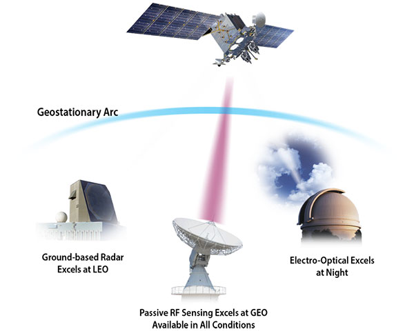 Examples of Space Domain Awareness observations utilized for strategic decision making
Venture capital firms like Decisive Point and Geospatial Alpha recently helped the Virginia-based space tech startup SCOUT with a bridge round to advance the company’s development of autonomous spacecraft vision and guidance. The SCOUT Vision System integrates optical, lidar, hyperspectral, RF, GPS and other sensors and utilizes onboard AI/ML processing to improve navigation safety and reduce complexity.
Venture capital investments in space exceeded $17 billion in 2021, or roughly 3% of total global venture capital flows. While most of those funds were directed toward rockets and satellites and were raised in late-stage rounds, there is a growing recognition of the need to invest in space domain awareness. VC firms backing SDA solutions are focused on maintaining a safe, secure and high-tempo operational environment and they’re looking for players who are demonstrating unique capabilities to achieve that.
As the domain becomes more complex, SDA technology will be essential to protecting not only individual assets but the entire network of space-based critical infrastructure powering the global economy, supporting national security and enabling the continuous reach beyond Earth.
Explore More:
Open-Source Intelligence Is a Key Ingredient of Holistic SDA
Data Fusion Leverages All Datasets for Better SDA
Non-Earth Imaging (NEI) Brings a Clearer Picture to SDA
Opening Eyes: Small Businesses Tackle Space Domain Awareness
DoD’s Commercial Space Domain Awareness Dilemma