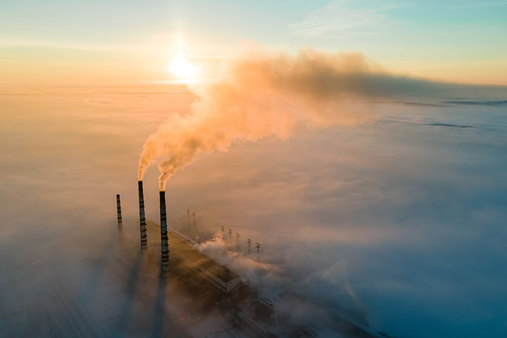
 Satellites designed to measure greenhouse gases are an increasingly important resource for the accurate monitoring and reporting of emissions. (Source: Bilanol/Shutterstock)
WASHINGTON – New emissions reporting rules proposed by the U.S. Environmental Protection Agency could usher in an expanded role for satellites in combating climate change.
Published Aug. 1 in the Federal Register, the rules would allow U.S. oil and gas companies to use satellite and airborne measurements, in concert with other data, to report their greenhouse gas (GHG) emissions. The provisions are part of a package of proposed changes designed to increase the accuracy of mandatory emissions reporting.
The push comes amid – and in recognition of – a proliferation of satellite-based GHG monitoring capabilities worldwide, with governments, private companies and nonprofits getting into the act. A report released in 2021 by the intergovernmental Group on Earth Observations counted more than 30 such missions, most of which are already on orbit and operational, with others planned for deployment the coming years.
These systems are designed to measure concentrations of one or more of three gases linked to global warming – methane, carbon dioxide (CO2) and nitrous oxide – with varying degrees of sensitivity and precision. Industry can use the measurements to detect methane leaks and track progress against certain Environmental, Social and Governance (ESG) commitments, while governments can use the data to verify the accuracy of companies’ emissions reports and track progress toward their net zero goals.
“The value proposition for space will likely be further accelerated by the growing importance of satellites in monitoring industrial emissions, a key contributor to climate change,” said Lori Garver, former NASA deputy administrator and currently chief executive of EarthRise Alliance, a philanthropic initiative dedicated to utilizing satellite data to address climate change.
On one end of the GHG monitoring spectrum are highly capable but relatively course-resolution satellites, mostly government owned, that measure GHGs on a global scale to support climate change research. At the other end are more specialized, lower-cost satellites operated by for-profit companies like GHGSat, which is focused primarily on methane.
Funded to date primarily by venture capital, GHGSat currently operates nine small satellites in sun-synchronous polar orbit, with more on the way. Each satellite is equipped with GHGSat’s patented hyperspectral sensor technology, which is precisely calibrated for methane detection at resolutions of 25 meters – sharp enough to detect and pinpoint the sources of leaks from industrial activities such as mining, energy production and landfills.
Stephane Germain, founder and chief executive of Montreal-based GHGSat, said that with the exception of the sensor, the company relies on commoditized capabilities, including ground stations and cloud-based data processing. Because hyperspectral sensors generate so much data, GHGSat is making extensive use of artificial intelligence (AI) for processing, he said.
“We’re making significant strides in using AI to detect emissions and process the data to deliver intelligence to customers,” Germain said. “That is absolutely nontrivial in the world of emissions. We’re looking at wisps of smoke – squiggly wiggly things that change in an instant. It’s a little different than counting cars.”
GHGSat’s customers to date include oil and gas companies, hydroelectric power companies, environmental groups and government agencies. NASA recently awarded GHGSat a task order to provide methane data in support of the agency’s Earth science research goals.
“In the future, as more and more people realize the value of accurate, measured emissions, I’m optimistic that this is going to open up very [large] derivative markets,” Germain told Constellations.
Environmentally conscious investors, for example, might want to know which companies are making efforts to reduce their carbon footprint. Some industry experts envision an investor guide in the form of a globally accepted carbon emissions rating system.
Governments, meanwhile, could use satellite data in the future to track not only emissions within their own borders, but also those of trading partners, potentially for the imposition of a carbon tax, Germain said.
Although other companies are planning hyperspectral satellites with methane detection capability, Germain said these other systems are more broadly focused.
Then there is MethaneSAT, which is being developed by the Environmental Defense Fund, a global non-profit dedicated to fighting pollution and climate change.
Slated to launch in 2024, MethaneSAT is a single-satellite system designed to quantify regional-scale methane emissions from oil and gas operations worldwide, down to areas of about 1 square kilometer. On its website, MethaneSAT says its satellite will be able to identify and quantify emissions from large sources, quantify aggregate emissions from smaller sources and track emissions from agriculture, landfills and other activities.
Germain sees the two systems as complementary. With its wide area coverage and ability to detect large emissions, MethaneSAT could be an important cuing tool for the higher-resolution GHGSat satellites, he said.
Jon Coifman, a spokesman for MethaneSAT and the Environmental Defense Fund, did not respond to requests to be interviewed for this story.
GHGSat’s constellation, meanwhile, is set to expand in the coming months. The company has three more satellites slated for launch this year, and recently ordered another four that will launch no earlier than 2024.
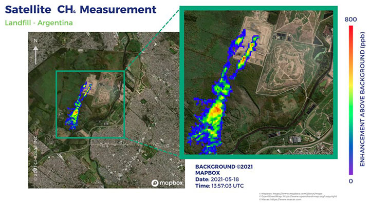 A satellite image provided by GHGSat indicating the presence of methane at a waste management site in Buenos Aires, Argentina in May 2021. (Source: GHGSat)
Unlike the current satellites, the upcoming satellites will be owned and operated by cubesat operator and manufacturer Spire Global, which also has responsibility for launch and licensing. The sensors, built by global technology company ABB, will continue to be owned by GHGSat.
Germain said there are appeals to the space-as-a-service operating model. “We’re not a manufacturing business; we’re a data business.”
But GHGSat is not committed to that approach, he said, adding that satellite ownership makes the company a more technically savvy buyer of services.
GHGSat is not exclusively committed to methane monitoring. The sensor on one of the three satellites launching this year is calibrated for CO2, which is more difficult to monitor than methane because of its background presence in the atmosphere. The application is also a bit different: Whereas the methane monitoring is heavily focused on leaks, Germain sees the CO2 sensor as helping companies validate emissions estimates.
GHGSat has some success stories under its belt already. Recently, the company detected a methane concentration a few kilometers down the road from a landfill it had been monitoring in the United Kingdom. When GHGSat called the utility responsible, they were at first skeptical. But a closer examination confirmed the leak, and they dispatched a repair team to fix it, Germain said.
“That one leak was probably the equivalent of tens of thousands of cars taken off the road for a year,” Germain said.
Germain said that adding up similar examples over the past two years, GHGSat has helped companies mitigate 5.6 metric tons of CO2-equivalent emissions, a measure that can be calculated from methane quantities. “That’s like taking 1.25 million cars off the road for a year,” he said. “That’s pretty decent-sized city.”
Explore More:
Podcast: Space Debris, Climate Change and Euthanasia for Satellites
Euroconsult: 5 Takeaways from World Satellite Business Week 2023
Podcast: Billions Served: 5G Nanosatellites to Extend Globe IoT Footprint
Satellite IoT Opportunities: Drilling into Oil and Gas